This story goes back to a meeting of the City Council's South Area Committee on 5 October (and yes, I missed it at the time - although in my defence I was out of town...). As part of the "Open Forum" that's a standard item on area committee agendas, the minutes record the following:
"Mr Storer raised concerns regarding cyclists riding into bollards (generally in the dark) on the cycleway alongside the guided busway. He queried if the bollards were needed."
The minutes go on to record a few comments made on this topic, and a final action - writing a letter to the County Council, requesting further information.
So, now to the latest meeting of that committee (14 December). This generated a response from the County Council. This covers the status of the track adjacent to the Busway, and then goes on to address both the lighting and bollards used. One interesting sentence reads: "As a result of comments received about the bollards we have used a different design on the recently completed extension of the busway that will serve the new Cambridge North station." The number and location of bollards is also to be reviewed.
It's hard to read this, I think, without taking away from it a certain acceptance that the bollards already installed along the busway may not always be the most suitable - although you won't find any direct admission of that in the County's letter.
And then, in the Cambridge News of 17 December, comes an article giving details of a cyclist who was badly injured after hitting one of the bollards near the Hills Road bridge. At no point does the Cambridge News article refer to the South Area Committee's coverage of this issue - it may be that it's entirely coincidental timing that the article appeared just a few days after the committee heard from the County Council, but the balance of probability suggests otherwise.
Needless to say, if you want to know more about this topic - from the cyclists' perspective - then the Cambridge Cycling Campaign's latest newsletter has fuller coverage. Two articles, indeed.
Pending any changes, the message to cyclists using the bridleway/cycle track alongside the Busway appears to be: take care! I don't think that applies just to the bollards, though...
Showing posts with label cycling. Show all posts
Showing posts with label cycling. Show all posts
Sunday, 20 December 2015

Saturday, 14 November 2015
Study on Beneft of Busway on Commuters Health
A study has been published in the American Journal of Preventative Medicine examining the health benefits of the guided busway to 469 adult commuters who live within 30km of Cambridge.
It concluded that "Providing a new sustainable transport infrastructure was effective in promoting active commuting" (i.e. walking / cycling.)
Read the details here
It concluded that "Providing a new sustainable transport infrastructure was effective in promoting active commuting" (i.e. walking / cycling.)
Read the details here
Monday, 1 December 2014
New cycle spaces at Swavesey and Longstanton
New cycle parking spaces have been installed at Longstanton Park & Ride recently.
This week, the cycle storage area at Swavesey is being enlarged.
This week, the cycle storage area at Swavesey is being enlarged.
 |
| Swavesey Busway Stop - cycle storage area |
Wednesday, 23 July 2014
Bus and cycle link to Cambridge Science Park railway station
Work to create a road/cycleway link between the guided busway and the new Cambridge Science Park railway station is stepping up.
The cycle/pedestrian underpass under the old railway in Milton Road will close - cyclists and pedestrians will be diverted to the other side of Milton Road. Motor traffic will continue on Milton Road throughout the operation in both directions, but traffic may be diverted onto a bus only lane. This phase of the work will be completed in March 2015.
The station is expected to open in May 2016.
Read more at
Cambridge News
Sunday, 29 June 2014
Tour de France
The Tour de France cycle race will be in Cambridge on Monday 7th July. The city centre will be closed off to traffic for the whole day, and all busway services will be affected. Services A, B and C will not be able to serve the city centre.
Full details can be found here.
Service A from St Ives direction will terminate at Chesterton Milton Road all day on 7th July. Timetable here. Map of bus stops here.
Service A will also run between Cambridge Railway Station, Addenbrooke's and Trumpington P&R. Details at http://www.stagecoachbus.com/uploads/buswayapr88tdf.pdf Map of bus stops here.
There won't be any buses on route A between Milton Road and Cambridge Rail Station.
Route B will be terminating in Chesterton Lane. Timetable here and map showing location of set down and pick up point is here.
Whippet website does not yet give exact details of how their service C will be affected.
Information about road closures for the Tour can be found here and here
Full details can be found here.
Service A from St Ives direction will terminate at Chesterton Milton Road all day on 7th July. Timetable here. Map of bus stops here.
Service A will also run between Cambridge Railway Station, Addenbrooke's and Trumpington P&R. Details at http://www.stagecoachbus.com/uploads/buswayapr88tdf.pdf Map of bus stops here.
There won't be any buses on route A between Milton Road and Cambridge Rail Station.
Route B will be terminating in Chesterton Lane. Timetable here and map showing location of set down and pick up point is here.
Whippet website does not yet give exact details of how their service C will be affected.
Information about road closures for the Tour can be found here and here
Wednesday, 25 December 2013
Christmas floods on the busway
Merry Christmas to all readers of the busway blog!
It's not such merry news for those of us who cycle the busway. I walked along the busway between the gravadlax and the turkey early this afternoon, and the Great Ouse River is in flood. Water is now covering the busway cycle track at the concrete bridge a short distance east of the Ouse Viaduct. I was a bit surprised to see that the water is flowing through that concrete bridge from north-east to south-west ( that's left to right on the first photo, and right to left on the second).
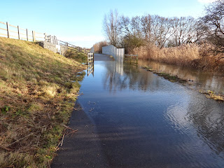

I'll keep checking the water levels over the next few days and post details on the blog.
Boxing Day update - the big dip between St Ives Park & Ride and the Ouse Viaduct is now under water, and the flooded section beyond the viaduct has extended both directions from the concrete bridge. So probably 400 metres of the cycle track under water.


Update - 7 January.
This photo shows the flooded cycle track between Fen Drayton and Swavesey.
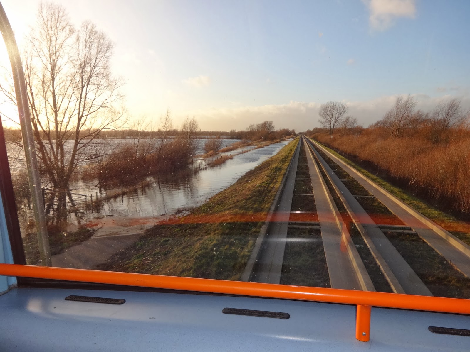
Update 9 January.
I walked along Low Road towards Fenstanton this afternoon and here is the state of the road at Crystal Lakes. Although the road is 'closed' several cars drove through the flood apparently without difficulty and a cyclist made it through.

It's not such merry news for those of us who cycle the busway. I walked along the busway between the gravadlax and the turkey early this afternoon, and the Great Ouse River is in flood. Water is now covering the busway cycle track at the concrete bridge a short distance east of the Ouse Viaduct. I was a bit surprised to see that the water is flowing through that concrete bridge from north-east to south-west ( that's left to right on the first photo, and right to left on the second).

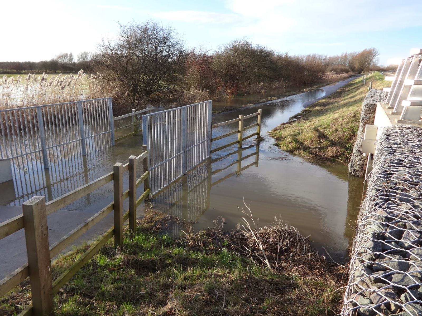
I'll keep checking the water levels over the next few days and post details on the blog.
Boxing Day update - the big dip between St Ives Park & Ride and the Ouse Viaduct is now under water, and the flooded section beyond the viaduct has extended both directions from the concrete bridge. So probably 400 metres of the cycle track under water.


Update - 7 January.
This photo shows the flooded cycle track between Fen Drayton and Swavesey.
Update 9 January.
I walked along Low Road towards Fenstanton this afternoon and here is the state of the road at Crystal Lakes. Although the road is 'closed' several cars drove through the flood apparently without difficulty and a cyclist made it through.
Wednesday, 18 December 2013
Cambridge Science Park rail station approved
Cambridgeshire County Council has approved the planning application for the new railway station at Chesterton serving the north of the city.
This will involve an extension to the guided busway.
Several details of the scheme are causing concern, including the safety of proposed cycle lanes.
More information here.
This will involve an extension to the guided busway.
Several details of the scheme are causing concern, including the safety of proposed cycle lanes.
More information here.
Thursday, 21 February 2013
Busway flooding - article in Cambridge News
The Cambridge News has highlighted the dangers people are exposing themselves to because of the persistent flooding of the guided busway cycle track. Click here to read the article.
There is a photograph by Nick Richardson showing someone cycling along the concrete tracks. Mr Richardson has contacted the County Council's guided busway team to ask what measures the Council could take to ensure the floods would not impede the public's use of the track. He received a reply to say that a flood risk assessment had to be undertaken, and that the Environment agency had to give agreement to any works since the track crosses the River Ouse Flood plain.
Councillor Roy Pegram is quoted as saying that the track 'would inevitably be closed from time to time because of flooding as it was built on a flood plain and the Environment Agency wanted to ensure maximum flows of water'.
That sounds very close to saying there's nothing that can be done.
But let's remember, we're not talking here about a few days of flooding. The track has been flooded continuously since 28 January. It's been under water 80 days since 23 November, and 100 days since 1 May.
The current flooded section (between Fen Drayton Lakes and Swavesey) is caused by water that entyered some fields and ponds when the river level was exceptionally high, but has no way of escaping back to the river now that the river has returned to more normal levels.
The genuine flood plain section close to the River Ouse viaduct floods quickly and then tends to dry up quickly when the river level falls.
If you are a user of the busway track for walking or cycling, I urge you to contact your County Councillor to push for improvements.
Also reported in Huntingdon & St Ives News & Crier ( 21 February, page 3)
There is a photograph by Nick Richardson showing someone cycling along the concrete tracks. Mr Richardson has contacted the County Council's guided busway team to ask what measures the Council could take to ensure the floods would not impede the public's use of the track. He received a reply to say that a flood risk assessment had to be undertaken, and that the Environment agency had to give agreement to any works since the track crosses the River Ouse Flood plain.
Councillor Roy Pegram is quoted as saying that the track 'would inevitably be closed from time to time because of flooding as it was built on a flood plain and the Environment Agency wanted to ensure maximum flows of water'.
That sounds very close to saying there's nothing that can be done.
But let's remember, we're not talking here about a few days of flooding. The track has been flooded continuously since 28 January. It's been under water 80 days since 23 November, and 100 days since 1 May.
The current flooded section (between Fen Drayton Lakes and Swavesey) is caused by water that entyered some fields and ponds when the river level was exceptionally high, but has no way of escaping back to the river now that the river has returned to more normal levels.
The genuine flood plain section close to the River Ouse viaduct floods quickly and then tends to dry up quickly when the river level falls.
If you are a user of the busway track for walking or cycling, I urge you to contact your County Councillor to push for improvements.
Also reported in Huntingdon & St Ives News & Crier ( 21 February, page 3)
Monday, 11 February 2013
Flooding update - 11 February
The busway cycle track is still under water between Fen Drayton and Swavesey. There's a longish section of about 200 metres, plus a shorter stretch. I was on a bus so couldn't see how deep the water was.
Has anyone tried to cycle or wade through the flood in the last day or two?
Has anyone tried to cycle or wade through the flood in the last day or two?
Friday, 23 November 2012
Busway cycle track flooded
Today (23 November) the cycle track is flooded for about 200 metres east of the Ouse Viaduct.
The heavy rainfall of the last few days in the Great Ouse's Northamptonshire and Buckinghamshire headwaters is likely to reach St Ives over the weekend, so I'd expect the water level to rise even further.
The busway cycle track seems to me to be susceptible not so much to the amount of local rainfall, but to water coming down the river from its huge catchment area after periods of heavy rain. I think the river authority tries to control the flow of water by using the section between St Ives Lock and Brownshill Lock (Earith) to hold water back, probably in order to minimise closure of the main road at Earith Bridge. I think we need to campaign for having the cyle track through the floodplain raised by another meter or more.
The heavy rainfall of the last few days in the Great Ouse's Northamptonshire and Buckinghamshire headwaters is likely to reach St Ives over the weekend, so I'd expect the water level to rise even further.
The busway cycle track seems to me to be susceptible not so much to the amount of local rainfall, but to water coming down the river from its huge catchment area after periods of heavy rain. I think the river authority tries to control the flow of water by using the section between St Ives Lock and Brownshill Lock (Earith) to hold water back, probably in order to minimise closure of the main road at Earith Bridge. I think we need to campaign for having the cyle track through the floodplain raised by another meter or more.
Wednesday, 14 November 2012
Tron Legacy
Histon guided busway stop was the venue for the creation of a series of images by Simon Haydn and Laura Aldred . The images, inspired by the 2010 science fiction film Tron:Legacy, are intended to encourage cyclists to use lights. See Cambridge News for full story and a slideshow.
Tuesday, 17 July 2012
Bicycle thefts on busway
Police are trying to crack down on bicycle thefts which have been happening at cycle parks on the guided busway. According to the Cambridge News , police officers will be visiting busway stations between 7.30am and 9am (Tuesday 17th July), between 7.30am and 9am and from 4pm to 6pm on Wednesday 18th July , between 4pm and 6pm on Thursday 19th July, and on Friday 20th July between 7am and 8.30am and from 4pm to 6pm.
Thursday, 7 June 2012
Extension of busway across Stourbridge Common
The Cambridge News reveals that environmental campaigners are concerned that the guided busway might be extended to run across Stourbridge Common, and ancient meadow on the north-east fringe of Cambridge city. In fact, the proposal is merely to ensure that a strip of land adjacent to the railway line is safeguarded for possible future use, though no specific plans have been made for a busway extension at this time. A County Council spokesman has said that the plans to open a new station at Chesterton will reduce the need to extend the busway across the Common. However, plans are going ahead to create a cycle route (the Chisholm Trail) alongside the railway.
Saturday, 5 May 2012
Flooding on the busway
Today (Saturday), as I travelled to work in the relative comfort of a Stagecoach bus, I noticed that the water level on the flooded section of the busway cycle path has now risen a few more inches. It was lapping at the top of the concrete bridge that takes the cycle track over what must be intended as a flood channel. This is situated a few metres east of the Ouse Viaduct.
 Nearby is one of those brick 'art installations' that were erected along the busway a few months ago. The 'installation' was almost submerged. So I reckon the water is close to two feet, maybe three feet deep.
 This is too deep for cyclist to plough through (as they have been doing the past few days), and so this morning there were several cyclists wheeling their bikes along the grass verge at the top of the busway embankment, dangerously close to the buses which at this point travel at 56mph.
 The flat area of grass at the top of the embankment is only about a metre wide, so people are putting themselves into danger. There is very little margin for error between getting hit by a passing bus and sliding down the embankment into the water. The busway cycle track has proved hugely successful as both a leisure route for cyclist, walkers, and runners, and as a travel-to-work route for cyclists. Is it too much to ask that Cambridgeshire County Council raise the level of the track even more so that the cycle path becomes an all weather route?


Monday, 2 April 2012
Safety for cyclists
Warning marks have recently been painted on the busway's cycle track at several places, to help cyclists to avoid hazards such as bollards.
 At Histon, there is a footpath which crosses the busway. They've painted white lines to try and direct cyclists away from the busway at the crossing.


Wednesday, 14 March 2012
Cycling improvements
The cycle track which follows the guided busway has been so successful that The Department for Transport has agreed to fund improvements to the Thicket path east of St Ives. This path links St Ives and Huntingdon, and is effectively a continuation of the busway track. The £30 million comes from the DfT's 'Linking Places Fund'. Although 43% of British people own bicycles, only 2% of journeys are made by bike. Improvements to the Thicket path have potential to attract cyclists from Huntingdon who want to continue their journeys from St Ives towards Cambridge by bus or cycle . Hunts Post, 14 March, page 4
Tuesday, 16 August 2011
Cycling along the busway
Monday morning, as my weekly ticket had run out, I decided to cycle to work. This was my first experience of the newly tarred cycle track from Swavesey to Cambridge. Very smooth and fast - just a pity about the steep gradients in and out of some of the hollows that had been flooded in the winter. In fact, there remains one puddle on the St Ives to Swavesey section, which still has a gravel surface. Does anyone know when it is being tarred?
One thing that surprised me was how quiet the buses seemed as they glided past.
I came off the guideway at Histon, and reaching my work via Arbury Road, part of Milton Road and Elizabeth Way. I made good time - 56 minutes door to door.
I returned on the Service A from Parkside. This was unfortunately delayed as the driver thought he'd knocked a cyclist off her bike as he overtook her in Emmanuel Road. He was mightily relieved that she said he hadn't hit her bike, and she was unharmed. I think she had wobbled as the bus went past. That delay of 5 or 6 minutes meant that my door to door journey ( walk, bus, walk) took 54 minutes.
One thing that surprised me was how quiet the buses seemed as they glided past.
I came off the guideway at Histon, and reaching my work via Arbury Road, part of Milton Road and Elizabeth Way. I made good time - 56 minutes door to door.
I returned on the Service A from Parkside. This was unfortunately delayed as the driver thought he'd knocked a cyclist off her bike as he overtook her in Emmanuel Road. He was mightily relieved that she said he hadn't hit her bike, and she was unharmed. I think she had wobbled as the bus went past. That delay of 5 or 6 minutes meant that my door to door journey ( walk, bus, walk) took 54 minutes.
Subscribe to:
Posts (Atom)