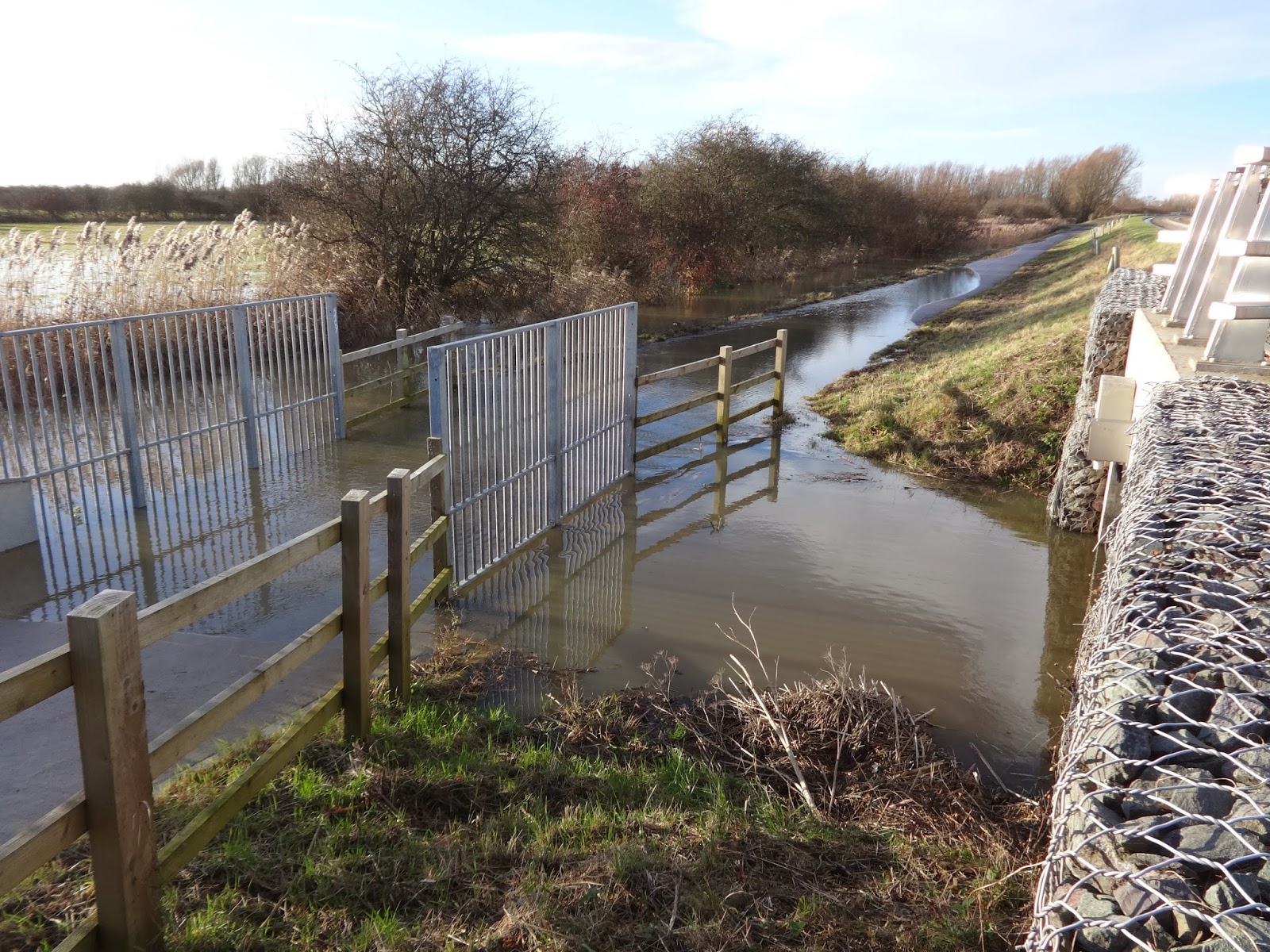
It's not such merry news for those of us who cycle the busway. I walked along the busway between the gravadlax and the turkey early this afternoon, and the Great Ouse River is in flood. Water is now covering the busway cycle track at the concrete bridge a short distance east of the Ouse Viaduct. I was a bit surprised to see that the water is flowing through that concrete bridge from north-east to south-west ( that's left to right on the first photo, and right to left on the second).

I'll keep checking the water levels over the next few days and post details on the blog.
Boxing Day update - the big dip between St Ives Park & Ride and the Ouse Viaduct is now under water, and the flooded section beyond the viaduct has extended both directions from the concrete bridge. So probably 400 metres of the cycle track under water.


Update - 7 January.
This photo shows the flooded cycle track between Fen Drayton and Swavesey.

Update 9 January.
I walked along Low Road towards Fenstanton this afternoon and here is the state of the road at Crystal Lakes. Although the road is 'closed' several cars drove through the flood apparently without difficulty and a cyclist made it through.

Thanks for this I was going to go and have a look as I am back to work tomorrow, but I now know what to expect, I will update n what the rest is like but thanks Andrew
ReplyDeleteI'm in work tomorrow, do you know if it's flooded by fen Drayton lakes? I will find out tomorrow
ReplyDeleteI didn't go along the track as far as Fen Drayton Lakes, just the first section to the small concrete bridge. Can you let us know what you find tomorrow?
ReplyDeleteAlso, does anyone know whether Low Road is still passable?
Low road looks no different this afternoon around 3 pm.
ReplyDeleteThis comment has been removed by the author.
ReplyDeleteThe track between Swavesey and Fen Drayton was still clear this afternoon, but the water in Covell's Drain appeared to be higher than the track down in the dip to the west of it. Water was flowing across Holywell Road to the Ferry Lagoon.
ReplyDeleteHowever, according to the Environment Agency records of the river level at St Ives, it peaked about midnight last night.
As David has pointed out the track at Fen Drayton was clear this morning (06:00), however after the rain last night I wouldnt be suprised if that part of the track floods today. Also, why hasnt the gate closed at St Ives to warn people of the flooding? not that anyone pays any attention to it.
ReplyDeletePossibly because the County Council has been on holiday? And how regularly do they inspect the cycle track?
DeleteAlso, I dont think there is going to be any more rain until Monday, so hopefully the flooding will go down.
ReplyDeleteRiver levels at St Ives tend to lag behind the rain by about 3 days. This is because the river collects rainwater over a huge area including Towcester, Milton Keynes, Bedford, St Neots, and Biggleswade. So we might see water levels continuing to rise even though the rain has stopped. I seem to remember from last time that the section between Fen Drayton and Swavesey filled up with water and stayed under water even after the river had gone down.
DeleteWell as at 6.30 tonight, first 2 dips from St Ives flooded as Andrew has mentioned, water level is not above the concrete bridge thing. Third dip along the way, just past that wooden fencing before the tree lined avenue part is just starting to flood, but passable by bike. All the rest is clear, as if nothing has happened. No signs or fences closed saying anything is flooded.
ReplyDeleteAfter cycling back to st Ives from cambridge tonight more floodiding is appearing after the first lake on the right hand side, it's the first dip after the existing flooding. However it was a great underwater light show!
ReplyDeleteThanks to everyone for this up to date info. I'm back to work on Jan 2, but on a recumbent trike with zero tolerance for flooding. I observed the high waters from the bus itself when I went into town on Friday - no passage at Fen Drayton on either side of the concrete ramp (where it says SLOW), and little change between early afternoon when I went in and early evening when I returned.
ReplyDeleteI seriously hope the path becomes passable again by Thursday as the commute to work is a vital part of my fitness routine and if I can't do it I must get up at 4am to do it on stationary bike at home.
Last year the floods seem to have just staid in place for the entire winter, but I was not yet monitoring them on a daily basis. Does anyone have stats or observations on how quickly we can hope for drainage after reaching flood levels? Andrew said a 3-day delay from rain to river levels but there could be more delay from river levels to busway drainage.
Happy New Year to all,
EFR
You could cycle via Fenstanton, Fen Drayton and Swavesey on ordinary roads, but only as long as Low Road isn't flooded (it was open yesterday when I went past in the car). This diversion might add 10-15 minutes onto your journey.
DeleteArtemisia, you ask about how often the cycle track has been flooded. Here are some statistics: 19 days of floods in May 2012, 4 days in July 2012, 60 days in Nov 2012 to Feb 2013 and 14 days in March/April 2013. The sections that are flooded at the moment will probably dry out quickly once the river level drops, but there's no sign of that yet.
DeleteJeepers, that's a lot - even worse than I thought.
DeleteI hesitated moving to St Ives because of this, but there was no other choice because I really could not afford Cambridge.
If only that goddam path could be fixed! But I hear there is neither money nor intention to do anything about it.
Im assuming people use the grass verge to pass the water?
ReplyDeleteThey do. And indeed today ( when I was on the bus) I saw some cyclists cycling on the bus track. I wouldn't recommend walking on the grass verge beside the busway to avoid the water. You are very, very close to the passing buses - one false step and you could slide down the embankment, a false step the other way and a bus could hit you.
DeleteThe ride round the villages from Swayvsey to St Ives is ok at the moment - made a nice change today although was very windy!.
ReplyDeleteLow road was clear this morning but ominously the car park/lawn at the fishing place had some flooded areas so will be interesting to see if it stays dry and for how long!
Artemisia - Hello! I see you often riding the opp direction to me :-) (Black and Blue Giant road bike)
So are you the guy who says hi to me? Hi to you too, and Happy New Year.
DeleteI understand that this afternoon there is only a short bit of water at the bottom of the concrete ramp east of the St Ives viaduct - and if you stick to the busway side of the track it is passable on a normal bicycle. (approx 2" deep)
ReplyDeleteThere is however, some debris left by the floods - but nothing like as bad as last winter.
As David Parish said, I got home by not having to get off at all, a little flooding after the bridge going to St Ives but easily passable on the bike, brilliant!!
ReplyDeleteI came home on the bus yesterday evening around 5pm and still saw more flooding than I would want to undertake on a recumbent, but I'm glad for the upright cyclists.
ReplyDeleteUnfortunately it's raining again, and on Look East they predicted more flooding in the area over New Year, so I think more disruption is likely over the next few days.
All gone except for a few inches and about 3 metres from the concrete bridge. Marvellous!
ReplyDeleteAny know what conditions are today 02/01/14.
ReplyDeleteThanks
After cycling to cambridge and back to st Ives the cycle track is now clear of flooding but the ditches are still full of water so if we get some heavy rain it will flood again
ReplyDeleteRiver levels going up and tempest threatening, so I expect we'll have another bout of flooding next week. ;+<
ReplyDeleteBusway flooded at the normal spots but sections between Swavsey and the reserve looked ok for now. Low road is flooded but I have been informed the improvements at Earith have worked and there is no flooding.
ReplyDeletemajor flooding this morning (06:00) at the first dip, concrete bridge and at the first dip after the bridge. I was suprised that fen drayton has not flooded, but i suppose that could happen today. Does anyone know what the low road looks like?
ReplyDeleteUpdate - 5 January - Water was still lying on the cycle track on Sunday 5 January, between St Ives Park & Ride and the viaduct, and east of the viaduct both sides of the small concrete bridge. I'd guess it was only about 6 inches deep as people were wading through it in wellies.
ReplyDeleteRiver levels still rising steeply:
ReplyDeletehttp://www.environment-agency.gov.uk/homeandleisure/floods/riverlevels/120732.aspx?stationId=6178
St Ives around the Dolphin hotel largely underwater this morning, and the ground in my yard so sumpy that the builders cannot repair the fence that blew down 3 weeks ago.
As for triking to work, I've given up. I guess I'll just have to join the Gym instead.
6th Jan 2014 - It's still very, very flooded. I caught the bus for the first time ever today, and I'm glad I did.. 100s of metres of the path were under water. Someone will eventually get killed or seriously injured walking on the busway itself and then the council might do something.
ReplyDeleteill be going on the busway tomorrow morning so will report back.
ReplyDeleteFlooding is starting to appear alongside fen Drayton lakes
ReplyDeleteIt's now flooded between Swavesey and Fen Drayton (the third dip as you travel west from Swavesey). Water is flowing at two places from the Ferry Lagoon into the Far Fen Lake and the Trout Pond. For a map showing the names of these lakes see http://www.cambridgebirdclub.org.uk/sitepages/fendr.htm
ReplyDeleteCycling from Cambridge to Needingworth in a bit, should be fun...
ReplyDeleteA foot/cycle bridge over the Ouse at Holywell would shorten the cycle journey from Cambridge to to Needingworth.
DeleteOh god that would be amazing, take 1/3 off my journey!
DeleteOnce the stretch past the Trout Pond is flooded, it will be flooded for some weeks, as once flood water gets in there it is very slow to drain out - this is always the last stretch to clear.
ReplyDeleteIf you look south along Covell's drain (wedge shaped concrete hump on the cycle track) when the water recedes, expect to see the water in the Trout Pond higher than the level in the drain.
Looks like its the A1123 to Earith and Willingham, only a few miles more!
ReplyDeleteLooks like I'll be doing that route for a month or so until the flooding goes
DeleteA very bad road, and pretty deadly on a recumbent in the dark and in bad weather, so I don't know that I can follow suit. Oh dear, I fear I shall be getting very fat!
DeleteLOW RD CLEAR THIS MORNING
DeleteLow rd tomorrow then, the A1123 is a bit hairy!!
ReplyDeleteLow Row is dangerous as well. In fact getting out when the Low road is flooded is pretty hard if you want to stay alive!
ReplyDeleteTell tell me about it, tried it tonight and it was awful, car drivers are we're idiots tonight on the low road. Won't be doing the low road again
DeleteWell I'm running out of routes to avoid the flooding, my only option seems be the busway itself
DeleteWent through low Rd at half 5pm, was filling up again. Must of been another peak come down the Ouse. Someone told me to try using the single Rd fro Fenstanton to A14 junction the wrong way, says it's OK even if a car comes down it. Maybe we could ask for a cycle path to be put in. In fact I'm going to that.
ReplyDeleteGood idea.
DeleteLow road was very flooded this morning - cars just able to pass but it looked deep, so i went down that litte road parallel to the a14. It isnt nice riding it the wrong way around (or very safe) so im not quite sure how im going to get home from Huntingdon to Waterbeach tonight...
ReplyDeleteEarith and the A1123 maybe but thats quite busy nornally
@steve think earith after the lock is flooded. Go through St ives up Somersham Rd but turn past tip towards bluntisham, go through earith and on to Haddenham then down six pence Lane.
ReplyDeleteThe gates are closed at Earith lock at the moment, but there are plenty of cars coming through anyway.
ReplyDeleteI ploughed into the water last night in a comedy fashion. went up to my knees.
ReplyDeleteWet last 30 min cycle home!
Anyone know if the low Rd is clear today?
ReplyDeleteWater levels are down slightly at all the places the cycle track is flooded. But still not possible to cycle between St Ives and Swavesey along the busway.
ReplyDeleteThe road from Fen Drayton village to Fen Drayton Lakes bus stop is under water.
When I came past the low road at Vindis it was still showing as shut and that was early afternoon.
ReplyDeleteMaybe the buses should allow bikes on from St Ives to Swavesey!
ReplyDeleteThe low road is open again, no water on the road.
ReplyDeleteI understand folding bikes are being carried on bus between St Ives & Swavesey - whether that is officially allowed I don't know.
ReplyDeleteThe first dip on the busway as you go out of st ives just before the viaduct was clear of flooding, I couldn't see the concrete bridge though. However fen Drayton lakes are still flooded
ReplyDeleteCame back via the bus way tonight, all the dips from St Ives up to Fen Drayton Lakes either water free or passable by bike. Just the 2 big dips from Swavesey up to St Ives are heavily flooded, with some water encroachment on the first dip from Swavesey. But the tricker section to navigate is now bike friendly :)
ReplyDeleteFolding bikes are allowed on buses
ReplyDeleteThanks to everyone for keeping us posted about the state of the cycle track.
ReplyDeleteIs there a lot of debris on the track where the water has receded? Do we need to ask the Council to sweep the path?
Yes there is quite a bit of debris it would be good to ask the council to clear it
DeleteProbably good if several people contact the Council.
ReplyDeleteDoes this mean the busway is passable by bike from camb to st Ives or do I still need to go via fen Stanton?
ReplyDeleteIt's dried out between St Ives and Fen Drayton (except for a puddle next to the concrete bridge) . However, there is a huge amount of debris on the track. Between Fen Drayton and Swavesey there is still water lying, so you'd have to divert via some of the rough tracks. If it was me, I'd still go via Fenstanton.
ReplyDelete@Andrew - Many thanks for this. At least low road is now open again!
ReplyDeleteI noticed tonight that the council have cut the grass verge between longstanton and swaversey it finishes at the bridge and they have not cleared the mess they have made! I thought they had finished cutting?
ReplyDeleteWhen this happens I am pleasantly reminded that the road route is so much better than boredom of the busway, and it's not as busy as you would think either. Double bonus is Huntingdron rd out of Cambridge rather than Histon rd, so much easier.
ReplyDeleteI'll try huntingdon road next week
DeleteI tend to use Gilbert Road and Histon Road when cycling.
ReplyDeleteJust the one section flooded now, the first dip after the concrete 'speed bump' from Swavesey still too deep to cycle thru.
ReplyDelete@James Barlow,
ReplyDeleteI read your comment with interest, I thought it was just me who thought the busway gets just so monotonous. But I find the fact it saves me 2.5 miles which in winter on my MTB is worth it, just! I just wish there was a better way back into St Ives, as the A1096 is not pleasant and the Low road is a death trap at 6 pm, and the cycle path is shocking. I have never known anything like it, its like being cut off when things are flooded, I cant believe that car drivers put up with the congestion!
@kevin I find the low Rd alright at 6pm, no where near as busy as it used to be now the dairy is shut. Then again I tend to go at 40km/h down the middle so they can't overtake.
ReplyDeleteSunday 19 January - the water level seems to have gone up slightly near the River Ouse and the track is now flooded at several places between St Ives Park & Ride and Fen Drayton. It's not very deep though - several people were cycling through the water OK. seemed. Two flooded sections still between Fen Drayton and Swavesey. the road from Fen Drayton village to the bus stop has dried out.
ReplyDeleteI finally received a reply to my idea for a cycle route from vindis-a14-one way Rd to Fenstanton. Bullen us passing on the idea, maybe it will be place by next winter.
ReplyDeleteAnother note, somewhere in the dip coming down from Longstanton to Swavesey, glass has been smashed on the cycle route. I had a very very flat as I come up the rise at the farm track crossing. Only one hole in tube but I did dig out 5 bits of glass from my front and 3 from my rear.
Thanks for the heads up on the glass, it will be useful for tomorrow morning. Nice cycling with you last week, I will tryout huntingdon road this week
DeleteYes think I'm sticking to road route for now, every other ride ends in flat tyres.
ReplyDeleteJon, cheers for the tow, I hate headwinds big front area, as soon as i pull out its like hitting a wall. I will be going girton-oakington-longstanton-swavesey-fen Drayton-Fenstanton-low Rd. Most cars leave room and wait to pass, better than pedestrians and Joggers in black on the busway.
No probs, I will start that route tomorrow morning as it's more interesting than the busway and there's no debris
DeleteWhen coming out of Longstanton towards Swavesey which way do you go? The old Over Road past the housing estate used to bring you out via an unmarked footpath about 200m from the Over/Swavesey roundabout - but last week I found there are closed gates across that road now (although easily walked around). I saw no signs indicating it is closed.
Delete@ Jon didn't fancy Huntingdon rd- Girton last night then? went past you at the 2nd lights after Castle Hill.
Delete@David go through the village as if going to Busway, but turn left at the roundabout instead of going down towards Willingham. Follow bypass straight across at the roundabout then onwards to Swavesey, in Swavsey turn left then take the right up past the Pikey site.
DeleteI saw you and thought about following you but was already commited to Histon Road. I went through Girton and down Huntingdon road this morning and it was great. I will be doing that route from now on. What time do you normally head off home?
DeleteHi guys I've set this up so people can post conditions https://groups.google.com/forum/#!forum/cambs-cycling-route-reports
ReplyDeleteGood idea, James. I've added a link to your forum. It's under Busway Links in the right hand column of the blog.
DeleteAndrew - have you heard if the busway team are going to clean the cycle track where the flooding has been?
DeleteI've heard nothing from the Council. An email to my County Councillor will be the next thing to do.
DeleteThey won't do it until the track is drained all the way - the Multihog won't be able to get through the flooded dip at Fen Drayton lakes.
DeleteNext flood, how about a protest ride on the tracks?
ReplyDeleteNEXT flood? As if this one is ending any time soon?
DeleteI had a reply asking to find the money for my idea of an alternative route when everywhere is flooded, also didn't think it is worth it stating that "it's an infrequent occurence". what a bell end, has he forgotten people take to the tracks as a solution!
ReplyDeletewhy dont we just paint a white line wide enough for bikes?
DeleteIs this a contra-flow cycle lane on the 1-way road between Fenstanton and the A1096? I think a white line would be dangerous. It would give cyclists a false sense of security on what is a bit fo a race track. A cycle lane on a pavement might work though - but it would cost more. And while we are at it, what about a cycle track/footpath on the A1096 out as far as Galley Hill (A14 junction)?
DeleteStill safer than busway tracks in my opinion, but would also be temporary until low Rd is open properly. Speed restriction and temporary signage for access and warnings. Cheap solution.
DeleteThough considering cambs council announced they would be increasing safe cycle routes, this could be done properly and also connect Hilton.
I rode it twice while low Rd shut at 6am, two cars and both at the same bends before I got onto the straight part.
James - i went through Girton and Huntingdon rd this morning and it was much better, I will be doing the route from now on. Huntingdon rd is much better than Histon rd. What time do you normally head off home?
ReplyDeleteVaries depending on when I get in or need to be home for, normal about 5.
DeleteAndrew - we've had nearly 100 comments for this flooding article! is this the most comments you have had for an article?
ReplyDeleteYes, I think it is the most comments. I've also had the most number of visitors in a month - 5005 in the past 31 days.
DeleteThis is the latest reply I've received from the County Council:
ReplyDelete'In the recent rains during January the maintenance track has been flooded around the the Holywell ferry area. The water is now receeding and it is hoped by the end of the week the water will be sufficiently clear of the whole track to enable us to begin clearing the debris from it as we did last winter.
I have therefore instructed our grounds maintenance contractors to undertake the work.
The area the maintenance track occupies is in a dedicated flood plain and any further works to raise the track may have an effect on the overall drainage in the whole area. There is no identified funding to provide another solution at present.'
Thanks for the update Andrew, I think this is the 100th comment!
ReplyDeleteUpdate - Sunday 26 January - water is still lying on the cycle track between Fen Drayton and Swavesey.
ReplyDeleteI was the road now all the way into cambridge. My bike is a lot cleaner and you don't have to worry about flooding. I reckon it will take 2/4 weeks until it's clear, then you have all the debris it leaves behind
ReplyDeleteUpdate - Monday 27 January - water levels in the river have gone up again, and the track is now flooded bat three places between St Ives and Fen Drayton Lakes.
ReplyDeleteThe low road is not flooded despite the rain fall over the last couple of days. However, the water levels are high so if we get more rain then it will flood again
ReplyDeleteThe google group that James has set up is really useful to get live updates of the road route from St Ives to Cambridge, if anyone is interested
ReplyDeleteAnd there is a link from this blog.
DeleteUpdate - 2 Feb - water level has risen again so cycle track is under water at all the usual places between St Ives and Swavesey. the road from fen Drayton village to Fen Drayton Lakes bus stop is flooded.
ReplyDeleteWho can meet Saturday morning at 8am for slow protest ride up the tracks?
ReplyDeleteI would be up for a protest ride as due to the earith roadworks st ives is awful to get out of in the morning. Havent cycled to work since Dec. 20th 2013 due to it being too dangerous to use the roads to avoid busway flooding and too far for me to manage both fitness wise due to increased mileage and extra time required. I know before the track we had nothing but now its there they NEED to do just a little more work to make it a 365 day use path.
ReplyDeleteIts the 'not knowing if its passable or not'' that's the killer, and the fact that nothing is being done to improve Earith Bridge or low road flooding.
I would protest about action being needed in these 3 areas.
@Anom the roads down the old route51 cycle route are pretty safe and quiet. If you are going all the way too Cambridge from St Ives its only 2miles more, longer if looping round to get back on the busway. If you are going to the science park, best place to rejoin busway is Longstanton or after Oakington.
ReplyDeleteUpdate - 6 Feb. Water has gone down again between St Ives and Fen Drayton, but long stretches are covered with mud and debris. Still under water between Fen Drayton and Swavesey.
ReplyDeleteLow road closed today, the road route is the best cycle route to cambridge, how's the busway?
ReplyDeleteBusway cycle track flooded virtually the whole way between St Ives and Swavesey. So definitely not the way to travel on a bike.
ReplyDeleteBlimey, how many days has it been flooded this year? Or has it been flooded everyday since Xmas day?
ReplyDeleteSince Christmas Day - so that's 49 days I think. Previously we've had floods lasting 19, 4, 22, 24 and 30 days - total 99 days - well above their 'design' prediction of 31 days a year.
ReplyDeleteYep saw it this morning, there are parts I have never seen flooded before, its a complete waste of time and wash out, even the fence has disappeared on dip 3 up from Swavesey, and last week I put my foot down in the area just before the concrete bridge coming back to St Ives, it was dark but it turned out to a foot of mud and sludge.
ReplyDeleteLow road is flooded but passable on the bike which is my choice at the moment. Still could be worse, at least my house is not flooded.
The one way road that parallels the A14 is a good option if you want to avoid the low road, it passes the low road as you come into fenstanton
ReplyDelete@Jon. thanks mate, I tried that once and it was a bit hairy! So I think I will stick with the Low road for a bit!
ReplyDeleteLow Road is now clear (this morning) for those of you who use it, that said if the rain is as bad as what they say its going to be then im sure it will flood again over the weekend.
ReplyDeleteThe first load of sips are starting to clear again, the concrete bridge is still under some water, but the rest after Fen Drayton Lakes are the same couple of feet under, I think it will weeks before it clear, but boy what a mess!
ReplyDeleteLow was still clear this afternoon, no indication of any flooding
ReplyDeleteSunday 16 Feb - water level down slightly but busway cycle track still flooded between St Ives and Swavesey.
ReplyDeleteHow's the buway looking?
ReplyDeleteI don't think I will be back on the busway until the summer, the roads are much cleaner than the busway as my bike has less crap on it
ReplyDeleteVery wise, Jon. I went into Cambridge in the bus yesterday and the cycle track was covered in debris wherever the water had receded. The next time I cycle into Cambridge will be along the normal roads.
ReplyDeleteUpdate - 23 Feb. Cycle track dry between St Ives and Fen Drayton, but covered in debris at many places. Water still lying on track between Fen Drayton Lakes and swavesey.
ReplyDeletedid you see the erosion to the embankment?
ReplyDeleteI was on the bus so didn't get a close look.
DeleteCycled in from Needingworth for the first time in a month. Only had to get off my bike to walk once, and the debris wasn't too bad, bikes starting to be clearing a way through most of it
ReplyDeleteNeedingworth! on the Busway?
ReplyDeleteVia St Ives, I guess!
DeleteYep - via St Ives. bit depressing going back on yourself at the start...
DeleteToday I was able to cycle from Swavesey to St Ives along the cycle track.
ReplyDeleteThe stretch by the Trout Pond now has some dry patches visible, and if you stick to the busway side of the track the deepest water is about 5cm.
The debris on the slopes is much deeper.
The debris has been cleared.
ReplyDeleteJust a few puddles by Trout Pond and at bottom of concrete ramp near Ouse viaduct - nothing deeper than about 2-3 cm.